Polygon layers with Mapbox Studio.. and exploring
In the previous posts, we made two polygonal datasets for Central America:
 However, I'd like to be able to answer questions about these areas, like: Do people live there? How hard would it be to travel there? For this, we need to superimpose this data on a basemap (preferably, a highly detailed basemap so we can zoom way in). In the olden days, GIS packages had offline basemaps, and this can still be done by downloading and styling a dataset like Natural Earth. However, the far more flexible and modern way is to use a web map, which Mapbox Studio makes almost trivial:


#2: The mountains of NE Oaxaca ... but on the remote eastern side of the mountains, not where most people in Oaxaca live. Here, a large area has high rainfall, but only a small strip of land is at 750+/-200 m elevation. Looking hard enough, there are a few villages at that elevation, but they tend to be like San José Tenango, which is nestled into a valley with steep slopes, with little visible agriculture:

#4: Mountains of northern Chiapas. There are very few settlements here, but the ones I see like Chapultenango (elevation 640m, pop. 3129) appear to be using their land for grazing, not food crops. Tapilula (780m, pop. 7441) seems similar. Some indigenous villages like Chapayal Grande (pop. 1000, does not even exist in OSM .. until I add it) seem to have a patchwork of small fields around them (grazing or milpa, perhaps?)


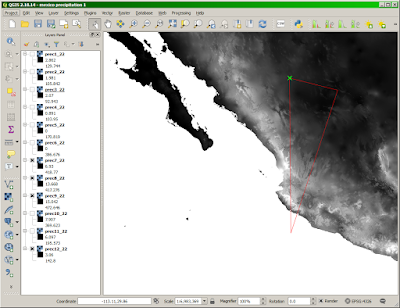
- areas with an elevation range of 550-950 m
- areas with a precipitation range of 2600-4500 mm

- After logging into Mapbox Studio, I click "New Style". It's slightly confusing that Mapbox refers to a whole set of data layers, each with its own style, as collectively a "Style", but that's what they do.
- I choose "Basic" as the style to start from, give it a new name and press "Create".
- To add a new layer, Studio distinguishes between:
- "Datasets" which are editable and dynamic and can't be uploaded from Shapefiles
- "Tilesets" which are static and can be uploaded from Shapefiles
- In this case, the data is static and it's in a Shapefile, so clearly we want a "Tileset". It's straightforward to zip up the data and upload it; Studio then takes a few minutes to grind away (presumably creating all those zoom levels of detail) and then we can add the "Tileset" to the "Style" as a Layer, starting with the elevation layer:

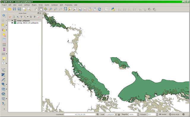
- Doing the same for the rainfall Shapefile, then styling them with two different colors, and 50% opacity: Blue for precipitation and Pink for elevation. The overlap can be easily seen as the purple areas:

- And the most delightful thing about web maps in the cloud: instantly shareable. I click "Publish Style", then "Share", and it gives me a shareable link you can visit right now.


Now we can pan and zoom and visually answer the questions. There are about 10 areas with significant overlap between the elevation and rainfall ranges:

Most of these can be ruled out quickly. #3 is a remote, uninhabited Biosphere Reserve. Northern Guatemala (#6) is also remote and seems to be barely populated, as are the spots in Jamaica, Puerto Rico, etc. (#7, #8, #9, #10).
That leaves:
#1: A wet, mountainous region NE of Mexico city, at the border of the Puebla and Veracruz states. Zooming in on Mapbox's OSM-derived basemap, it is a little difficult to tell to what degree the region is inhabited, due to sparseness of the OSM data here. On investigation, a lot of villages are missing, or miscategorized (hamlet instead of village). Despite those issues, there is clearly a lot of settlement here, like the village/municipalities of Zapotitlán de Méndez and Hueytamalco. There are even nice touristic Youtube videos telling you (in Spanish) how to get to Hueytamalco.

#2: The mountains of NE Oaxaca ... but on the remote eastern side of the mountains, not where most people in Oaxaca live. Here, a large area has high rainfall, but only a small strip of land is at 750+/-200 m elevation. Looking hard enough, there are a few villages at that elevation, but they tend to be like San José Tenango, which is nestled into a valley with steep slopes, with little visible agriculture:

#4: Mountains of northern Chiapas. There are very few settlements here, but the ones I see like Chapultenango (elevation 640m, pop. 3129) appear to be using their land for grazing, not food crops. Tapilula (780m, pop. 7441) seems similar. Some indigenous villages like Chapayal Grande (pop. 1000, does not even exist in OSM .. until I add it) seem to have a patchwork of small fields around them (grazing or milpa, perhaps?)

#5: Southern Chiapas, a region of high rainfall that runs all the way from sea level (the biosphere reserve "La Encrucijada") up through wide plains with some towns (Mapastepec, 50m) and finally up into the mountains:

There are a number of villages in those mountains, including Belisario Dominguez (700m, pop. 2000), although they seem to be only nestled along rivers surrounded by steep slopes, and little visible agriculture:

In Summary
There are indeed parts of Central America, particular Mexico, which are similar in elevation and rainfall to Ahualoa, Hawaii. However, they are mostly remote, almost all very steep terrain, and do not appear to be significantly agricultural, with the possible exception of area #1 above. It might be cool to further investigate places like Hueytamalco.
Comments
Post a Comment